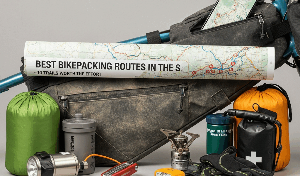
Best Bikepacking Routes in the US — 10 Trails Worth the Effort
The best bikepacking routes in the US will wreck you, rebuild you, and leave you planning the next one before you’ve even hosed the mud off your drivetrain. I’ve spent the better part of eight years riding loaded bikes across this country — from the red dirt of the Colorado Plateau to the soaking wet logging roads of the Pacific Northwest — and I’ve made enough bad decisions along the way to have strong opinions about which routes are actually worth your vacation days. This isn’t a database. It’s a ranked list from someone who has flatted in the wrong places, bonked in the wrong canyons, and once ran out of water 22 miles from the nearest resupply. Learn from that last one.
This article includes affiliate links. We may earn a commission at no extra cost to you.
How We Ranked These Routes
Every route on this list got scored across four categories before it earned a spot. Those categories are scenery, logistics difficulty, resupply access, and best season window. Each one matters differently depending on your experience level, which is exactly why the list is ordered from most accessible to most punishing rather than by some arbitrary fame factor.
Scenery is obvious but subjective, so I weighted it toward variety — routes that give you multiple distinct landscapes over their length score higher than ones that are beautiful but monotonous for 300 miles. The Smoke ‘n Fire 400 in Idaho, for instance, has relentless visual payoff. Some routes in the Southeast are gorgeous but you’re staring at the same tree canopy for four days straight.
Logistics difficulty accounts for navigation complexity, road surface, and how badly a mechanical failure will hurt you. A route where you’re 60 miles from the nearest town with no cell service on a Tuesday in October is a different animal than one where you cross a highway with a gas station every 40 miles. I rode one stretch of the Arizona Trail in 2021 where the nearest bike shop was in Tucson — I had a cracked dropout and duct-taped my way to civilization. Not ideal.
Resupply access is the underrated variable that most route write-ups gloss over. I’ve seen riders abandon otherwise manageable routes because they didn’t plan food carries correctly. Anything over 100 miles between resupply points requires serious food math. Routes with consistent 40–70 mile resupply intervals are genuinely more forgiving for first-timers.
Best season window matters more than people think. A route rated “difficult” in July might be downright pleasant in May. I factor in snow coverage, temperature extremes, and whether the roads become impassable mud in wet conditions.
Quick Reference — All 10 Routes at a Glance
| Route | Distance | Elevation Gain | Difficulty | Best Months |
|---|---|---|---|---|
| Katy Trail (MO) | 240 mi | ~1,500 ft | ⭐ Beginner | Apr–Jun, Sep–Oct |
| Virginia Creeper Trail Extension Loop | ~150 mi | ~12,000 ft | ⭐⭐ Easy–Moderate | May–Oct |
| Ozark Highlands Route (AR/MO) | 230 mi | ~25,000 ft | ⭐⭐⭐ Moderate | Apr–May, Sep–Nov |
| Cascade Gravel Grinder (WA/OR) | ~350 mi | ~40,000 ft | ⭐⭐⭐ Moderate | Jul–Sep |
| Coconino 250 (AZ) | 250 mi | ~23,000 ft | ⭐⭐⭐ Moderate | Apr–May, Oct |
| Arizona Trail (AZ) | 800 mi | ~100,000 ft | ⭐⭐⭐⭐ Hard | Mar–May, Oct–Nov |
| Smoke ‘n Fire 400 (ID) | 400 mi | ~55,000 ft | ⭐⭐⭐⭐ Hard | Jul–Sep |
| Colorado Trail (CO) | 535 mi | ~89,000 ft | ⭐⭐⭐⭐ Hard | Jul–Sep |
| Tour Divide (US/Canada) | 2,745 mi | ~200,000 ft | ⭐⭐⭐⭐⭐ Expert | Jun–Aug |
| Alaska White Mountains Loop | ~200 mi | ~18,000 ft | ⭐⭐⭐⭐⭐ Expert | Late Jun–Aug |
The 10 Best Bikepacking Routes in the US
1 — Katy Trail, Missouri
Distance: 240 miles. Elevation gain: roughly 1,500 feet total, which is less than some people climb on a single Saturday morning ride. The Katy Trail is a crushed limestone rail-trail running across Missouri along the Missouri River, and it is the most forgiving introduction to loaded touring in the country. Towns appear every 15–30 miles. Camping is plentiful and cheap — most trailside campgrounds charge $12–15 per night. No navigation required.
I’d recommend this one to anyone who has never slept in a tent with a bike before. The riding itself is flat enough that your legs can focus on getting used to the extra 25 pounds on your rack instead of also suffering through a 4,000-foot climb on day one. Best months are April through June when the wildflowers are going and the humidity hasn’t become oppressive. September and October are also excellent — the foliage along the river corridor is genuinely beautiful.
Tire recommendation: 40mm or wider. The limestone surface gets soft after rain and narrower tires will have you swimming. I ran 47mm Panaracer GravelKing SK tires on my last pass and they were perfect.
2 — Virginia Creeper Trail Extension Loop, Virginia
This one takes the famous Virginia Creeper Trail and builds a proper bikepacking loop around it using Forest Road 58, the New River Trail, and several connecting gravel roads through the Mount Rogers area. Total distance lands around 150 miles depending on your exact routing, but the elevation gain — approximately 12,000 feet — makes it feel longer. The Appalachian highlands up here are stunning in a way that photos don’t fully capture. Rhododendron tunnels, creek crossings, ridge views that stretch into North Carolina.
Best suited for riders with a couple of weekend overnights under their belt. The Forest Service roads are generally well-signed but a downloaded Gaia GPS track is non-negotiable. I learned that lesson the hard way on a misty morning near Whitetop Mountain when I missed a turn and added six miles of unnecessary climbing to my day.
Best months: May through October. Avoid leaf fall if you can — the leaves hide the road surface and make wet rocks invisible.
3 — Ozark Highlands Route, Arkansas and Missouri
The Ozark Highlands Route is criminally underrated. 230 miles, roughly 25,000 feet of climbing, through some of the most rugged and remote terrain in the Midwest. This is not flat Missouri rail-trail riding — the Ozarks will absolutely surprise you with how much vertical they’re hiding. Double-track, gravel forest roads, and a few short singletrack sections link together a route that passes through the Buffalo National River watershed, one of the most beautiful river valleys in the central US.
Resupply is workable but requires planning. Towns are small and grocery options are limited to gas stations or tiny general stores in places like Jasper, Arkansas — population around 500. Carry at least three days of food at any given point. Best season is April into early May before the ticks get completely out of hand, and again September through November when the hardwood color is exceptional and the air has some bite to it.
4 — Cascade Gravel Grinder, Washington and Oregon
Burned by route confusion on a previous Cascades trip, I spent two weeks researching the best north-south gravel corridor through the range before attempting this one. The result: a roughly 350-mile route linking Forest Service roads through the Okanogan-Wenatchee, Gifford Pinchot, and Mount Hood National Forests. Elevation gain tops 40,000 feet. The scenery is legitimately world-class — volcanic peaks, old-growth forest, glacier-fed rivers.
The logistics complication here is weather. The Cascades can snow at elevation any month of the year, and July and August are the only months where you have a reasonable expectation of clear high passes. Carry a puffy and a rain shell no matter what the forecast says. I use a Zpacks Arc Haul Ultra 60L for longer routes like this — comes in at about 15 ounces and handles the load fine with a good harness fit.
Navigation is genuinely complex. Multiple forest road networks intersect and not all of them appear accurately on digital maps. Download OSM-based maps in addition to whatever route GPX you’re running.
5 — Coconino 250, Arizona
250 miles. 23,000 feet of gain. Starts and ends in Flagstaff, loops through the Coconino and Kaibab National Forests, and spends most of its time between 6,000 and 9,000 feet of elevation. The route was developed specifically for bikepacking and it shows — it flows well, the resupply at Jacob Lake around mile 140 is properly positioned, and the terrain variety is exceptional. Ponderosa pine forest transitions into open juniper savanna transitions into red rock canyon country.
April and May are magic here. The snow has typically cleared from the higher sections, temperatures are comfortable, and you’re not competing with the summer monsoon season that makes afternoon riding genuinely dangerous in July and August. October also works well but you need to keep an eye on early season snow at elevation — it happens. A 2.4-inch or wider tire is worth it for the sandy sections in the southern half of the loop.
6 — Arizona Trail, Arizona
800 miles from the Mexican border to Utah. About 100,000 feet of cumulative elevation gain. This route earns its reputation. The Arizona Trail is the full commitment — two to four weeks depending on your pace, serious logistical planning, and some of the most demanding terrain in North American bikepacking. It crosses six distinct ecological zones, from Sonoran Desert to alpine tundra on the Kaibab Plateau, and includes sections that require hike-a-biking through rocky canyon terrain that no amount of gravel grinding prepares you for.
The resupply challenge is real. A few sections in the southern half require 80–100 mile food carries. The town of Superior around mile 300 is a legitimate resupply hub. Oracle before that, Flagstaff in the middle, and Page near the north end. Water sources need to be tracked carefully using the AZT Association’s water report — some listed sources are seasonal and unreliable in dry years.
Best window: southbound in March through early May, or northbound in October through November. Summer is not survivable in the desert sections — daytime temperatures exceed 110°F. I’ve ridden segments of this route three times over various years and consider the full thru as a serious project, not a casual vacation. Probably should have opened this section with that warning, honestly.
7 — Smoke ‘n Fire 400, Idaho
This is my personal favorite on the list. 400 miles. 55,000 feet of climbing. A loop out of Boise that circles through the Sawtooth, Salmon, and Boise National Forests, passing through some of the emptiest and most spectacular mountain country in the lower 48. The Smoke ‘n Fire runs in late July as a self-supported race but the route is rideable as a casual trip any time the snow is clear, which realistically means mid-July through September.
The route gets its name from the fire and smoke conditions that frequently affect Idaho in late summer, which is a real factor to monitor. In 2020 and 2021, air quality in the region was genuinely hazardous in August. Check airnow.gov before you go and have a bail-out plan. Despite that caveat, this route rewards with the kind of scenery that makes you stop pedaling and just stand there — granite cirques, wildflower meadows above 9,000 feet, rivers so clear you can count the rocks on the bottom from a bridge 30 feet up.
Resupply hits at Stanley around the halfway point — a tiny town with a surprisingly good general store and the Sawtooth Hotel if you feel like a real meal. Carry four days of food minimum between Boise and Stanley.
8 — Colorado Trail, Colorado
535 miles from Denver to Durango. 89,000 feet of climbing. This is the most technically demanding route in the lower 48 that still has regular resupply access, which is what separates it from the Tour Divide in terms of sheer survival difficulty. The trail spends the majority of its length above 10,000 feet, crosses the Continental Divide eight times, and requires a combination of singletrack and alternate routes (the Collegiate West and East alternates add significant riding) that demand real mountain bike skills on a loaded bike.
Most riders take 14–25 days. The resupply towns — Breckenridge, Leadville, Salida, Lake City, Silverton — are proper Colorado mountain towns with gear shops, real restaurants, and places to charge your devices. That support network is part of why the CT is so popular despite its brutality. July through early September is the window. Afternoon thunderstorms above treeline are a daily reality in summer — plan to be below 12,000 feet by noon.
A hardtail with 120mm of travel is the minimum I’d recommend here. Full-suspension bikes are genuinely faster on the singletrack sections and your body will thank you after day ten.
9 — Tour Divide, Montana to New Mexico
2,745 miles. 200,000 feet of elevation gain. The route follows the Continental Divide from Banff, Canada, to the Mexican border at Antelope Wells, New Mexico. It is the defining long-distance bikepacking route in North America and possibly the world. Riding it as a race means finishing in 14–20 days for the elite. Riding it as a tourist means 40–60 days of sustained effort through Montana, Idaho, Wyoming, Colorado, and New Mexico.
The Tour Divide is mostly unpaved — gravel roads, doubletrack, and some pavement connectors — and it is remote in a way that requires genuine self-sufficiency. Northern Montana through Glacier country has grizzly bear activity. The Basin section in Wyoming between Rawlins and Steamboat Springs is 150 miles of high desert with minimal water. New Mexico has sections where you won’t see another person for two or three days.
The Grand Depart race typically runs in mid-June, and that timing works well for the northern sections. Snow in Glacier is usually manageable by then and the New Mexico desert hasn’t
Stay in the loop
Get the latest adventure cycling world updates delivered to your inbox.